Center for Economic Development
Contact Information
Mailing Address
Cleveland State University
2121 Euclid Avenue, UR 354
Cleveland, OH 44115-2214
Campus Location
Urban Building, Room 355
1717 Euclid Avenue
Cleveland, OH 44115-2214
Contact Us
Phone: 216.523.7495
m.s.schnoke@csuohio.edu
Introducing the Waterfront Mapping Tool: Connecting the Development Dots
The Center for Economic Development, in partnership with the Greater Cleveland Partnership (GCP), the City of Cleveland, Cleveland Metroparks, and Cuyahoga County, proudly presents the Waterfront Mapping Tool, Connecting the Development Dots.
This interactive ArcGIS Online tool tracks ongoing and completed projects along Cleveland's lakefront and the Cuyahoga River, offering real-time details on project costs, timelines, and development phases.
The tool serves as a comprehensive resource for planners, developers, and stakeholders, providing a clear and organized view of Cleveland’s waterfront transformation.
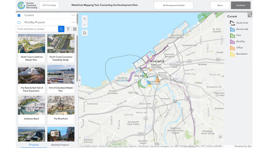
Featured Initiatives on the Waterfront
The Waterfront Mapping Tool highlights a variety of projects that are reshaping Cleveland’s shoreline. Here are some key initiatives:
North Coast Lakefront Master Plan
- Investment: $460 million
- Focus: Transforming Lake Erie’s shoreline with mixed-use developments, public parks, and better access.
- Highlight: The North Coast Connector Feasibility Study explores pedestrian bridges linking downtown Cleveland to the lakefront.
Irishtown Bend Project
- Investment: $100 million
- Focus: Stabilizing the riverbank to enable future neighborhood development and create green spaces along the Cuyahoga River.
Rock & Roll Hall of Fame Expansion
- Status: Under construction
- Focus: Enhancing a cultural icon by expanding capacity for events and exhibits.
Port of Cleveland Master Plan
- Focus: Improving port infrastructure to support economic activities, including shipping and trade.
Public Spaces & Mobility Enhancements
- Wendy Park Bridge: Connecting the urban core to green spaces.
- Scranton Flats Towpath Trail: Revitalizing the Towpath Trail for better connectivity and recreation opportunities.
Why Use the Waterfront Mapping Tool?
The Waterfront Mapping Tool consolidates diverse projects, offering:
- A centralized view of waterfront developments.
- Strategic insights for urban planning and development.
- A way to foster community engagement and enhance recreational opportunities.
Explore Cleveland’s waterfront projects and be part of the transformation!
Contact Information
Mailing Address
Cleveland State University
2121 Euclid Avenue, UR 354
Cleveland, OH 44115-2214
Campus Location
Urban Building, Room 355
1717 Euclid Avenue
Cleveland, OH 44115-2214
Contact Us
Phone: 216.523.7495
m.s.schnoke@csuohio.edu