Northern Ohio Data and Information Service
Contact Information
Mailing Address
Cleveland State University
2121 Euclid Avenue, UR32
Cleveland, OH 44115-2214
Campus Location
Urban Building, Room 32
1717 Euclid Avenue
Cleveland, OH 44115-2214
Contact Us
Phone: 216.687.3716
m.salling@csuohio.edu
Cleveland Maps
Cleveland City Map, effective 2020
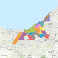
Cleveland City Ward Maps, effective January 2026
| Wards | |||||||
|---|---|---|---|---|---|---|---|
| Ward 1 | Ward 2 | Ward 3 | Ward 4 | Ward 5 | Ward 6 | Ward 7 | Ward 8 |
| Ward 9 | Ward 10 | Ward 11 | Ward 12 | Ward 13 | Ward 14 | Ward 15 | |
Interactive Map: Cleveland SPAs (aka Neighborhoods) and 2014 Wards
Zoom in and out and turn on SPA and Ward layers to see map details.
Cleveland City Map, approved January 2025
Statistical Planning Areas / SPAs (aka Neighborhoods), effective 2012
Maps are based on 2012 neighborhood boundaries and 2010 census tract geographic files. For additional information contact NODIS.
Older Cleveland city ward and neighborhood maps are also available.
Contact Information
Mailing Address
Cleveland State University
2121 Euclid Avenue, UR32
Cleveland, OH 44115-2214
Campus Location
Urban Building, Room 32
1717 Euclid Avenue
Cleveland, OH 44115-2214
Contact Us
Phone: 216.687.3716
m.salling@csuohio.edu